Jasmine — the city's flower
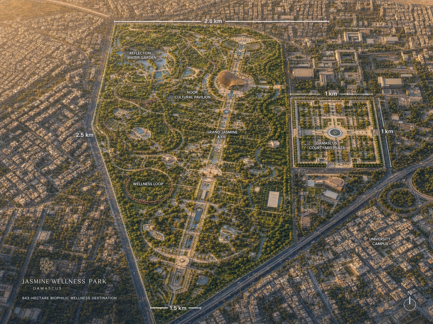
Damascus is the city of jasmine. The proposed Grand Jasmine Axis traces the scented bloom across the park, anchoring 1.5 km of formal promenade with water channels and seasonal planting.
Damascus · Syria · 33.5375°N, 36.3189°E
A 643-hectare biophilic wellness destination — weaving ancient Damascene wisdom into tomorrow.
Design Intent
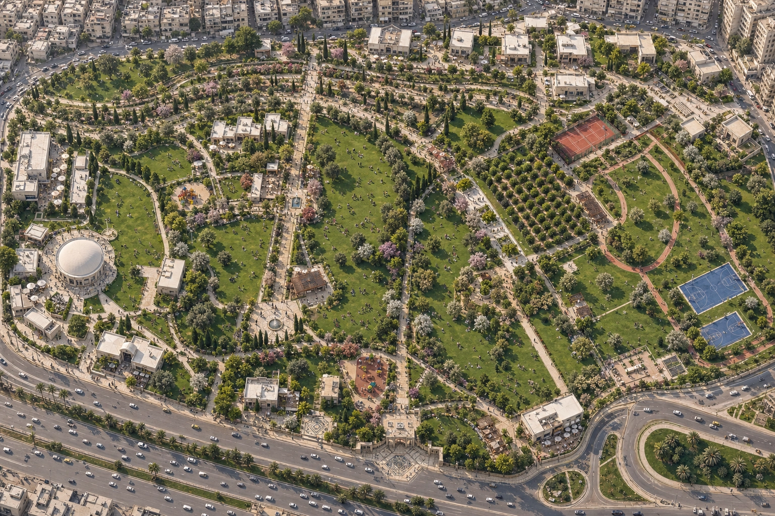
The proposal transforms Damascus' Abbou Jarash Gardens — historically part of the Ghouta oasis system — into a contemporary public realm. The intervention is precise: only available open land is reclaimed as park; existing built and under-construction areas are preserved and bordered. The result is a climate-responsive landscape, scaled from the Damascene courtyard, and inscribed with jasmine, water and shade.
01 · Vision & Context
Site Studies
02 · Master Plan
A north-south Grand Jasmine Axis threads the site, anchored by the Noor Cultural Pavilion in the north and a series of plazas, gardens and play zones across its length. Seven signature zones — click any number on the plan or any card below to explore.
03 · Masterplan Options
Six masterplan options for Al Adawi Park, each composed against the same site footprint and brief. Every plan is annotated directly on the render — zones, circulation, key features and entry points called out, with detail images below to convey atmosphere, materials and user experience.
04 · Master Plan Zones
05 · Signature Attractions
The marquee features that make Al Adawi a destination, not just a park. Each is sized and programmed to anchor a different mood — the icon, the promenade, the heritage room, the wellness circuit, the cultural stage.
06 · Annual Programme
Twelve months of programming calibrated to the Damascus calendar — bloom, harvest, festival, cool nights. The park reads the season; the season chooses the spaces it activates.
07 · Movement & Capacity
Four cardinal gates feed three primary circulation spines. The Grand Jasmine Axis carries the ceremonial weight; the Wellness Loop handles daily fitness; the Cross-Promenade ties the cultural east to the family west. Below: projected visitor numbers across the day, the week and the year.
Gates & Entries
Circulation Spines
Peak Times
08 · Daily Wellness Cycle
Eight time-bands choreograph the park experience from dawn jog to moonlit reflection. Each phase activates a different zone, programme and atmosphere — the park reads its own time and responds.
09 · Six Pillars of Wellbeing
The Keturah wellbeing framework, translated for a public park. Every space in Al Adawi belongs to one of six pillars — together, they sustain a complete daily rhythm of urban life.
10 · Material Palette
Every surface in the park is drawn from this palette — locally sourced, climatically appropriate, and chosen for the patina they earn over decades. Limestone from local quarries. Basalt from the Hauran. Olive wood reclaimed from the site itself.
11 · Render Gallery
12 · Identity & Climate
Damascus is the city of jasmine. The proposed Grand Jasmine Axis traces the scented bloom across the park, anchoring 1.5 km of formal promenade with water channels and seasonal planting.
The Ghouta oasis once ringed the city with orchards and irrigation. The park reasserts this ecological inheritance — olive groves, citrus, pomegranate, and ribbon canals reading the same landscape grammar.
Scaled from al-bayt al-dimashqi — the Damascene courtyard house — the plazas combine arcades, a central fountain and trees that shape an interior public realm against the heat.
Damascus summers exceed 38 °C. The park answers with dense canopies, evaporative water bodies, mashrabiya-shaded arcades, and an axis oriented for cross-ventilation. Native, drought-tolerant species reduce water demand.
The site connects pedestrian routes to Abbasid Square, Tishreen Park, and the Damascus University campus — closing a green corridor that has been fragmented for decades.
The Noor Cultural Pavilion's perforated dome is the park's visual signature — a re-reading of Umayyad geometry that casts shifting shadow across reflection pools through the day.
13 · Infrastructure Drawings
The project survey lives in 18 source files totalling 481 MB — buildings, roads, every utility,
topography and trees. We cannot render proprietary .dwg binaries directly in the browser, so each file
below is matched to its equivalent OpenStreetMap layer on the map further down. Click any card
to highlight that layer on the live map.
14 · Site Infrastructure
The existing infrastructure of Abou Jarash Gardens — 3,930 OpenStreetMap features fetched live via the Overpass API (buildings, primary & minor roads, vegetation, water, tree-cover) — overlaid on the same OSM tiles so the data and base map align perfectly. Pan and zoom anywhere on the map; toggle any layer to isolate it.