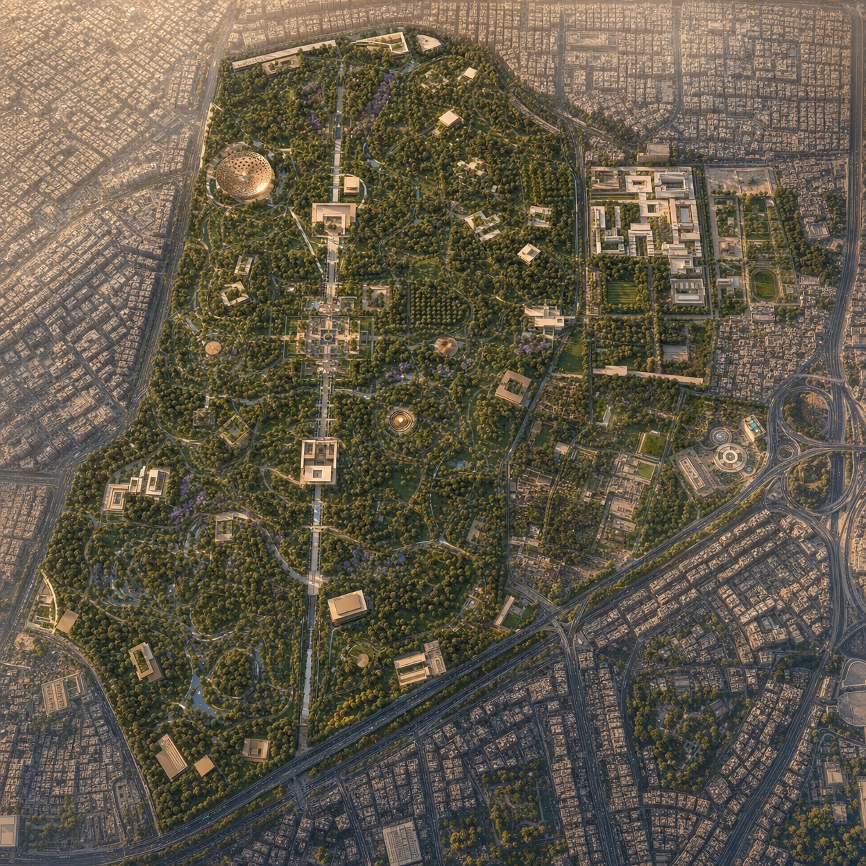
Aerial masterplan of Al Adawi Park within the Damascus street grid

Damascus, Syria · Feasibility Study

Can it be built? Yes — with three gates.

The full deliverability read for Al Adawi Park: land, access, utilities, water, ground, demand, cost, phasing, operations and risk — each factor examined, each gate named. Conceptual figures are labelled; the official survey confirms the rest.

01  The Verdict

Feasible — deliverable in phases, on its own water

7.6/ 10 · Feasible

The park can be built. Three gates decide the schedule, not the outcome.

The land is largely open and reclaim-led, access is strong on every edge, the walk-in catchment is huge, and the concept is climate- and craft-appropriate. Deliverability turns on: (1) confirming boundary & tenure, (2) proving the well-fed, near-zero-import water strategy, and (3) securing funding continuity across a multi-year build. None is unusual for a project of this scale; all are Phase-0 work.

≈300 ha
deed-verified plot (2,935,090 m², locked register); ~40 ha usable core opens first Verified
0
homes or active buildings taken — reclaim open land only
4
delivery phases — the park opens at Phase 1, not at the end
3
gates to clear in Phase 0: survey · water · funding line

Planning assessment The score is a structured planning judgement, not an audited rating — its factor-by-factor basis is the scorecard below and the deep-dives that follow.

02  Scorecard

Eight factors, scored and weighed

Feasibility scorecard

Composite planning judgement across the factors that decide deliverability. Planning assessment

Reading: the site's value case (scarcity, culture, access) scores high; the open items are evidence gates (water, survey), not design problems. Constraint load is real but moderate.

03  Land & Tenure

Reclaim-led land — the cheapest kind of big

What we know

Evidence

The site is dominated by open, formerly agricultural land (Abou Jarash gardens / Faculty-of-Agriculture lands). The masterplan takes only open land; existing buildings and under-construction plots are preserved and bordered. The plot is deed-verified at 2,935,090 m² ≈ 300 ha (16-vertex DWG hull, locked register); the drawn landscape boundary (109-vertex KML, ≈250 ha) sits inside it, with the 70/20/10 allocation fixed at 210 / 60 / 30 ha.

Why it matters

Reclaim-led delivery avoids the two things that kill urban parks: acquisition cost and displacement conflict. No homes are taken; the neighbours become the constituency, not the casualty.

Gate: cadastral survey + tenure register + authority sign-off on the boundary. To be validated

What could stop it — and the answer

Risk

Fragmented or disputed tenure inside the polygon; informal claims accumulating on open land while the project waits.

Answer

Phase 0 fixes the legal boundary first and physically demarcates and safeguards the open core immediately — presence (planting, fencing, ranger patrols) is the cheapest land-protection there is.

Score contribution: Deliverability 76/100 — high, conditional on the survey.

04  Access & Mobility

Strong edges, walkable core

What we know

Evidence

Road frontage plus a bounding boulevard; 1,246 road segments and 2,393 building footprints sampled around the site (OpenStreetMap); 8+ plausible pedestrian approaches; 68,000 residents within a 15-minute walk (radius-based).

Strategy

Perimeter parking and service, car-light shaded interior, gateways on every side so each district enters directly — the park joins the street grid instead of interrupting it.

Gate: safe signalised pedestrian crossings on the bounding roads, agreed with the traffic authority. To be validated

Access score: 82/100

Reading

The highest-scoring delivery factor. The catchment already walks; the constraint is crossing safety, not distance — a design-and-signals task, not a land task.

Transit

Multi-modal stops sit on the perimeter today; gateway placement aligns with them so arrival by bus or service taxi is step-free from day one.

Status: OSM-derived inputs Crossing plan to be validated

05  Utilities & Services

Two corridors, both plannable

What we know

Evidence

The project survey drawings flag a high-voltage electricity corridor and a sewer grading zone crossing parts of the site. Power, communications and drainage are available from the surrounding urban grid.

Strategy

Both corridors are kept as landscape-only zones — meadows, orchards and paths over them, no structures. They become linear green rooms, not dead strips; the layout absorbs them instead of fighting them.

Gate: utility as-built survey confirming alignments, depths and easement rules. To be validated

Cost & risk posture

Reading

No diversion is assumed — the plan works with the corridors in place, which removes the most expensive utility scenario from the base case entirely.

Services demand

Park loads are modest: irrigation pumping, lighting (solar-ready), pavilion power, toilets and drinking water. All within reach of the local grid with standard connections.

Score contribution: constraint load 55/100 — real, mapped, manageable.

06  Water Strategy

The hardest question, answered the Damascene way

What we know

Evidence

The site carries its own wells (project survey layer); Damascus receives only 130–202 mm of rain a year; the region is water-stressed. Any plan that imports mains water at park scale would be irresponsible — and would eventually fail.

Strategy

Near-zero-import: well-fed irrigation on a drought-tolerant, orchard-based palette; recirculating rills and mirror pools for cooling (moving water, minimal volume — the courtyard bahra logic at civic scale); night irrigation; soil moisture zoning; no thirsty lawn monoculture.

Gate — the project's single biggest evidence item: well-yield and water-table testing, plus a water balance for the planting plan. To be validated

Water score: 64/100 — the honest number

Reading

Scored lowest of the delivery factors on purpose: the strategy is sound and traditional, but unproven until the pump test. If yields disappoint, the fallback is a smaller irrigated core with larger dry-adapted meadows — the park shrinks its thirst, not its area.

Precedent

The Ghouta itself is the precedent: this exact land was productive orchard under careful water discipline for centuries.

Sequence: pump tests are Phase-0, before any planting design is frozen.

07  Ground & Environment

Former orchard land — the best possible inheritance

What we know

Evidence

Largely flat, formerly agricultural ground on the Ghouta edge; remnant orchard and mature trees survive on site; minimal demolition is required anywhere in the reclaim area.

Strategy

Retain and extend every healthy tree (instant canopy is unbuyable); reuse site soil; low-impact grading that respects the sewer-zone levels; excavated material reused for landform and wind shelter.

Gate: soil, contamination and tree survey. To be validated

Climate load

Reading

The environment section of the site analysis drives the brief: 40 °C+ heat waves demand shade-first design and evening-led summer operation — a programming answer, not a capital-cost explosion.

Biodiversity

An orchard-and-native palette restores habitat the green-belt collapse removed — an environmental return delivered by the same planting that cools the park.

Status: Verified climate inputs Ground surveys pending

08  Demand & Social Return

The demand is already standing at the fence

Feasibility is not only "can it be built" — it is "will it be used, and what does the country get back." The demand model says yes, immediately, and at scale.

68,000
residents within a 15-minute walk Radius-based
560,000
visits / year — working base case Provisional
5,000
design-day visitors at 80 m² each — comfortable, not crowded
10–15%
accessibility-sensitive visitors designed for from day one

Everyday dignity

A free, safe, shaded public room for districts that have almost none — the return is daily and immediate, not deferred.

Local economy

Craft market, food & beverage, guides, events and maintenance jobs; procurement in Syrian stone, brass, timber and trades keeps spend local.

National signal

The first metropolitan-scale park in Syria (see Parks of Syria) — a visible, replicable model of recovery.

Full model — scenarios, seasonality, age mix, personas — in People & Demand.

09  Cost & Economy

Where the money goes — and what keeps it down

No currency figure is claimed before the survey — pretending precision now would be dishonest. What can be said with confidence is the shape of the cost: which items drive it, and which decisions already made keep it low for the park's scale.

Relative capital-cost drivers

Index of relative weight, not currency. Planning assumption

What keeps cost down

  • Reclaim-led land — no acquisition or displacement bill
  • Low demolition — open ground, existing plots preserved
  • No utility diversion in the base case — corridors landscaped over
  • Local materials & trades — Syrian stone, timber, brass, craft
  • Phasing — capital spread; each phase opens and earns legitimacy
  • Water discipline — recirculation and wells cap the operating bill

Operating economy

  • Free at the point of use — a civic charter, not a revenue site
  • Capped concessions: market stalls, F&B, event fees fund a share of O&M
  • Seasonal staffing matched to the evening-led summer curve
  • University partnership carries the learning-garden programme
  • Gate: a committed operations & maintenance funding line before Phase 1 opens

10  Phasing & Delivery

Four phases — value from year one

The staging follows the house's own delivery lifecycle — Vision & Reading the Land → Design & Masterplan → Dialogue & Approval → Capital & Trust → Ground Breaking → Craft & Finish → Threshold & Handover — compressed here into four buildable phases.

Phase 0 · Enabling

Survey & safeguard

Cadastral boundary and tenure; well-yield pump tests and water balance; utility as-builts; soil, contamination and tree survey; physical demarcation and safeguarding of the open core; funding line committed.

Output: design freeze basisGate cleared: all three
Phase 1 · The Core

The park opens

The ~40 ha usable public core: family lawns, children's garden, the shaded loop, first gateways and crossings, wells and first rills, toilets, drinking water, lighting. Sized to carry the 5,000-visitor design day on its own.

Output: open parkPrereq: Phase 0 complete
Phase 2 · Landscape & Culture

Orchards, water & the Museum Without Walls

Ghouta orchard rooms, courtyard gardens and fountains, craft pavilions and the artisan market, the eight cultural nodes, the university learning edge.

Output: full-day destinationPrereq: water balance proven
Phase 3 · Completion

The full civic landscape

Remaining loops and gateways, festival grounds at event scale, the complete programming calendar, canopy reaching maturity across the site.

Output: metropolitan parkPrereq: O&M model running

11  Operations

Run like a civic institution, staffed like a garden

Governance

A public civic asset with a free-access charter; concessions capped so commerce serves the park, never the reverse; a single park authority accountable for the whole landscape.

Staffing & seasonality

A year-round horticulture and maintenance team scaled up for spring–autumn peaks; rangers and stewards on the evening-led summer schedule; local hiring first.

Partners

Faculty of Agriculture (botanical programme, learning garden), heritage and craft bodies (market, Museum Without Walls), schools (weekday programmes that fill quiet hours).

12  Risk Register

Ten named risks, each with its mitigation

RiskLikelihoodImpactMitigation
Boundary / tenure not confirmedMediumHighPhase-0 cadastral survey & authority sign-off before design freeze
Well yield below planMediumHighPump tests first; fallback palette shrinks irrigation, not park area; storage buffers
Funding gap mid-programmeMediumHighPhased delivery — every phase opens and stands alone; Phase 1 is self-sufficient
Summer heat suppresses daytime useHighMediumDeep canopy, water cooling, evening-led programme — designed-in, not remedial
Utility corridors constrain layoutHighLowLandscape-only over HV/sewer zones; confirmed by as-built survey
Encroachment on open land pre-deliveryMediumMediumPhase-0 demarcation, planting presence and ranger patrols
Construction cost inflation / supplyMediumMediumLocal materials & trades; phase-by-phase procurement; design-to-budget per phase
O&M funding drifts after openingMediumHighCommitted O&M line as a Phase-1 gate; concession income ring-fenced to maintenance
Crossing safety on bounding roadsMediumMediumSignalised crossings delivered with Phase-1 gateways, agreed with traffic authority
Over-commercialisation erodes civic characterLowMediumFree-access charter; capped concessions; civic-first governance

13  Validation Roadmap

Everything to confirm before design freeze

Land & approvals

  • Cadastral boundary & developable area
  • Tenure register
  • Authority approvals & planning status

Water & ground

  • Well yield & water table (pump tests)
  • Water balance for planting plan
  • Soil, contamination & tree survey

Utilities & access

  • HV & sewer corridor as-builts
  • Grid connection points
  • Crossing plan with traffic authority

People & operations

  • Current catchment population
  • Heritage & agronomic sign-off
  • Committed O&M funding line

All thirteen items are Phase-0 scope. Clearing them converts this study's provisional figures into a committed design basis — and turns the 7.6 into a green light.