The site analysis for Al Adawi Park — existing conditions, the measured boundary, the Damascus climate it must answer, its constraints, strengths and design principles. The full deliverability read lives in the companion feasibility study.
01 Site Context & Existing Conditions
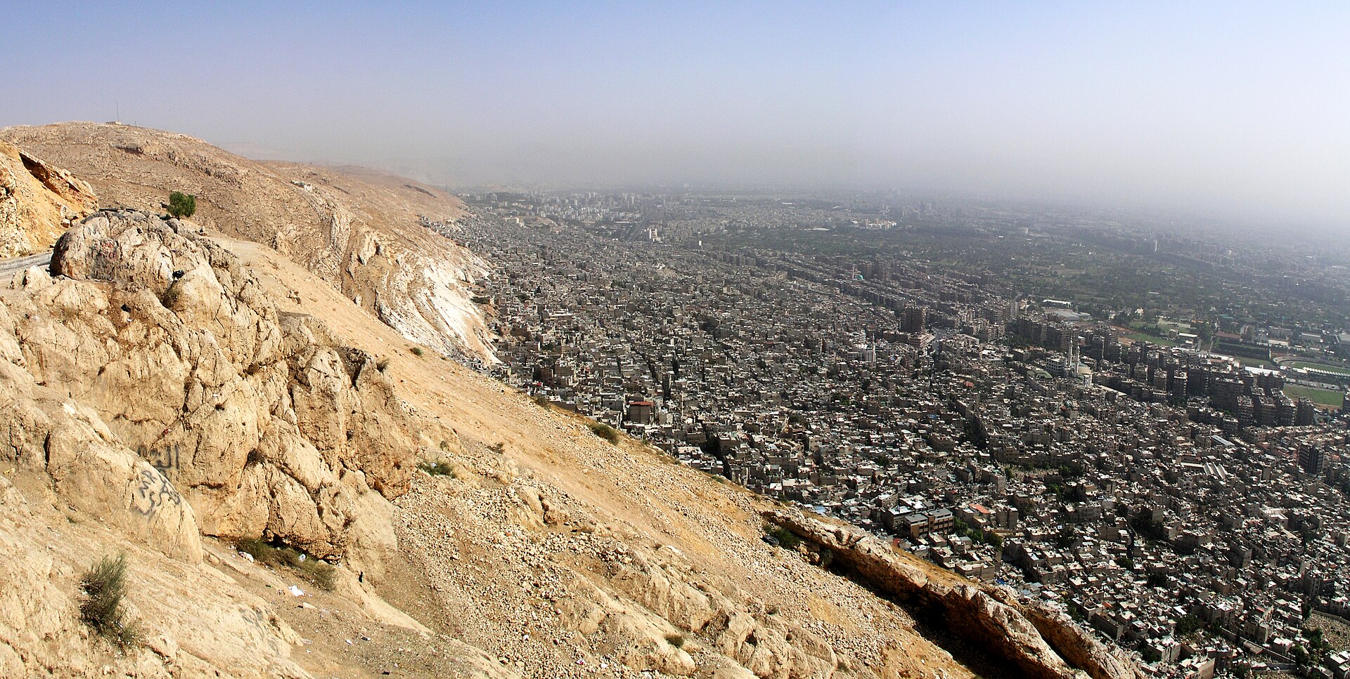
One of the last large open parcels in northern Damascus
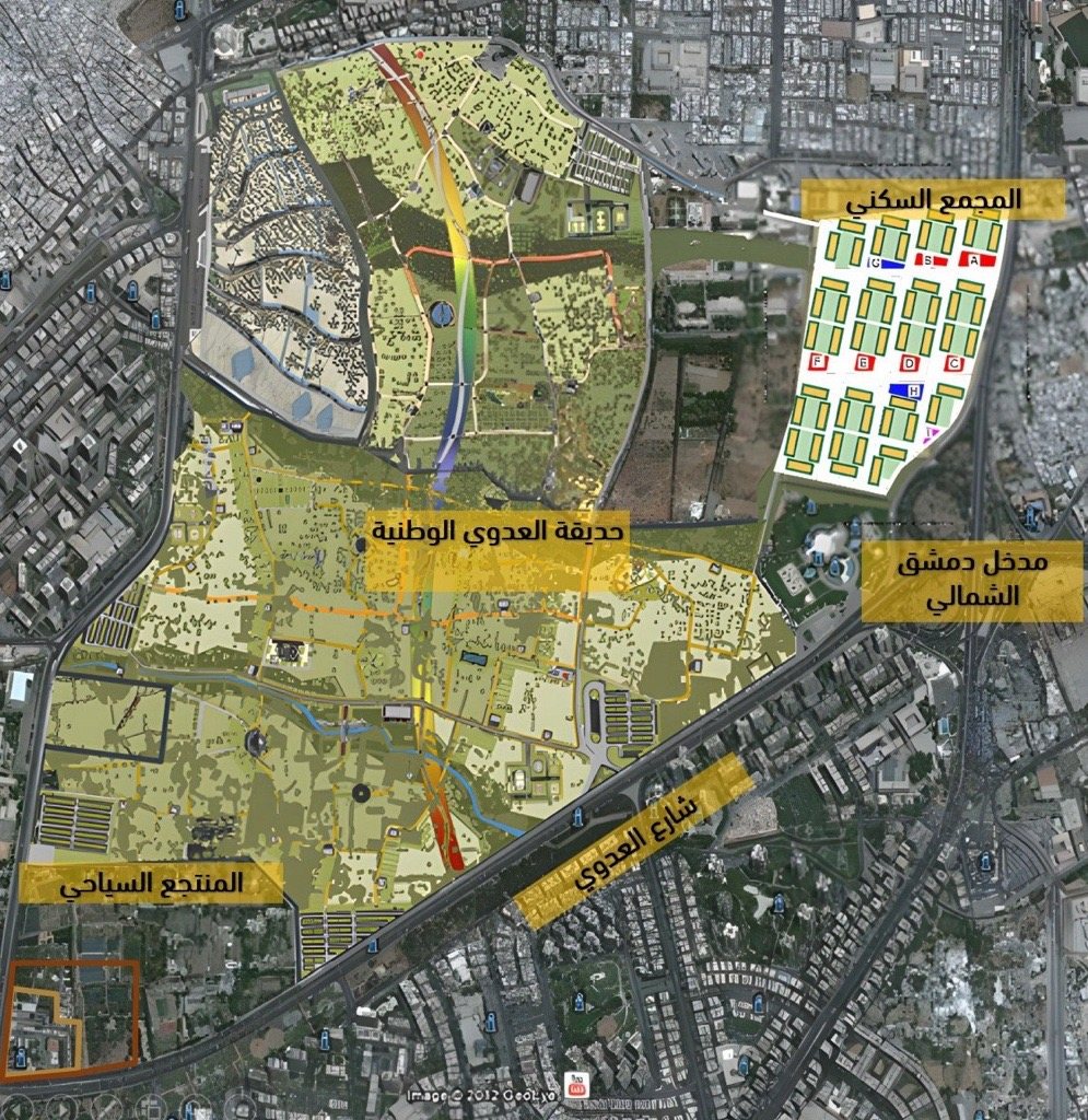
The site is the Abou Jarash gardens and Faculty-of-Agriculture lands at 33.5375°N, 36.3189°E — between the Rukn al-Din, Abu Jarash and Mazraa districts, below the southern slope of Mount Qasioun, on the historic edge of the Ghouta oasis.
≈300 ha
deed-verified plot — 2,935,090 m² (DWG register, locked) Verified
≈40 ha
usable public core (conservative scenario) Provisional
5,000
design-day capacity target
80 m²
space per visitor at the design day
Existing conditions inventory
Open / formerly agricultural land — the reclaimable core
Remnant orchard & mature trees (retain and extend)
Existing buildings & under-construction plots — preserved and bordered
Road frontage + a bounding boulevard; fine-grained blocks around
Site wells / water points (yield to be surveyed)
HV electricity corridor & sewer grading zone (survey drawings)
Surrounding fabric (OpenStreetMap sample)
Building footprints: 2,393
Road segments: 1,246
Water features: 42 · green polygons: 19
Anchors: Faculty of Agriculture, mosques, schools, clinics, markets, Abu Jarash mausoleum
A deed-verified plot — locked geometry, not a sketch
The plot is fixed by the DWG geometry register (27 May 2026, verified & locked): a 16-vertex deed hull of 2,935,090 m² ≈ 3,000,000 m² in Syrian Transverse Mercator (Levant Zone), independently cross-checked at 2,944,870 m². The drawn landscape boundary — the exact 109-vertex polygon from the project KML, ≈250 ha — sits inside it. Both are rendered live on the interactive map.
The official project program — the components on the plot
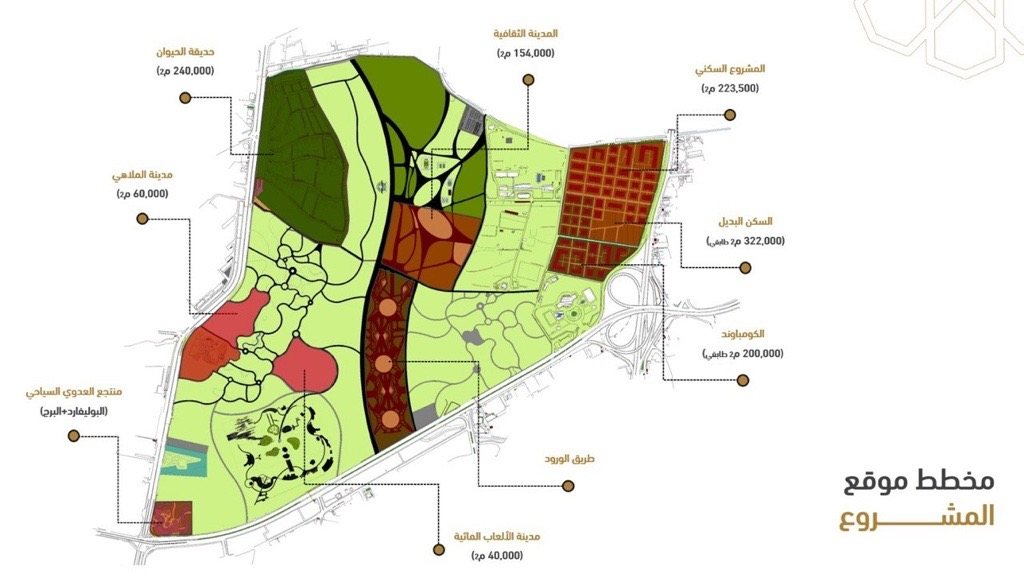
The government site plan (مخطط موقع المشروع) sets the program the wellbeing landscape is designed around: a national-park core wrapped by cultural, family-recreation, tourism and residential components, stitched by the Rose Road spine and the Al Adawi Street frontage. Areas below are transcribed exactly as annotated on the official plan.
Official project site plan · مخطط موقع المشروع — component zoning with annotated areas. Source: project masterplan document.
Component
بالعربية
Area (as annotated)
Cultural City
المدينة الثقافية
154,000 m²
Zoological Garden
حديقة الحيوان
240,000 m²
Recreation City
مدينة الملاهي
60,000 m²
Water-Play City
مدينة الألعاب المائية
40,000 m²
Residential Project
المشروع السكني
223,500 m²
Alternative Housing
السكن البديل
322,000 m² floor
The Compound
الكومباوند
200,000 m² floor
Al Adawi Tourist Resort — boulevard & tower
منتجع العدوي السياحي
—
Rose Road — landscape spine
طريق الورد
—
Official plan — as provided Areas transcribed from the annotated site plan (طابقي = built floor area). The tourist-resort tower corresponds to the iconic high-rise allocation in the deed register; the national-park core is the park-led majority. Final program subject to authority approval
04 Environmental Response
Sun, heat and a continental year
Damascus is hot-dry in summer and cool-wet in winter, sheltered from the sea by mountains. The design answers the sun and heat first — this is the single biggest driver of the plan.
Summer sun · Jun–Aug
High overhead sun, ≈28 °C average with 40 °C+ heatwaves; near-zero rainfall. Deep canopy + evening use.
Western afternoon sun
Strong low western sun stresses west-facing edges. Shade structures & tree lines to the west.
Winter · Dec–Feb
≈7 °C, lows near 0 °C, low southern sun; most of the 130–202 mm rain falls now. Sun-catching south terraces.
Water & dryness
Dry air, high evaporation. Moving water for cooling; drought-tolerant, low-water planting.
Wind & dust
Dry-season dust off arid edges and roads. Planted buffers & wind-aware axes for cross-ventilation.
Qasioun backdrop
The mountain frames every north-west view. Sightlines and arrival oriented to it.
Verified climate inputs Seasonal-comfort banding is Calculated; see the climate model.
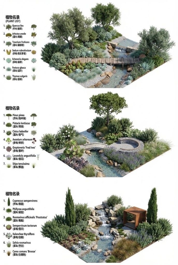
The planting answer — a drought-tolerant Mediterranean palette
Illustrative planting palette — three drought-tolerant garden typologies with species lists. Landscape design study.
≈80% Mediterranean & native species
The planting answers the heat and dryness directly — species that thrive on little water and read as local:
Backbone trees — holm oak, stone pine, Italian cypress, strawberry tree
Tree preservation — retain remnant orchard & mature trees
Boundary, access & edges
Official boundary & tenure — to be validated by survey / authority
Safe pedestrian crossings on the bounding roads
Institutional / residential buffers — quiet edges near homes & schools
Preserve built & active plots — reclaim only open land
Constraint load scored 55/100 — real but manageable; none is a stopper. To be validated
06 Entrances & Mobility
Seven gates, one parking building, a car-free heart
Every placement below is derived from the real geometry — entrances snapped to actual deed-hull vertices, roads taken from the live OSM network (no invented streets), pedestrian gates set where the mapped building density is highest. See it all on the interactive map's Mobility layers.
How visitors arrive
By car
From Al Thawra Street (primary, west) and Al Mothana Ben Al Haretha Street (primary, east), with 6th Tishreen Street (trunk) carrying the south-west approach — the three heaviest real frontages.
On foot
From the dense NE / E / N residential edges — 220, 189 and 185 mapped buildings within 250 m of the three pedestrian gates. The catchment already walks here.
Public transport
Multi-modal stops sit on the perimeter today (nearest ≈240 m); gateways align with them so arrival by bus or service taxi is step-free.
Inside the park
A single golf-cart loop links all 13 signature zones on the service spine — the pedestrian gardens stay vehicle-free.
Recommended entrances — 7, each with a job
Gate
Type
Where (real anchor)
Purpose
M
Main entrance
West frontage · Al Thawra Street
Arrival plaza, drop-off lay-by, parking building and cart hub — the ceremonial and vehicular front door
S
Secondary entrance
East frontage · Al Mothana Ben Al Haretha
Relieves the main gate on weekends, festivals and event days
P1
Pedestrian gate
North-east edge (220 buildings / 250 m)
Direct walk-in from the densest neighbourhood edge (Rukn al-Din side)
P2
Pedestrian gate
East edge (189 buildings / 250 m)
Everyday local access; nearest to the university edge
P3
Pedestrian gate
North edge (185 buildings / 250 m)
Serves the northern blocks; evening-promenade entry
SV
Service entrance
Quiet south-west edge
Deliveries, maintenance and horticulture — out of visitor sight
E
Emergency access
Quiet south-west edge
Clear apparatus route, kept free of daily traffic
Real geometry Gates sit on actual boundary vertices beside named OSM roads. Planning proposal Final positions follow the traffic-authority and survey gates.
Golf-cart circulation
One loop · 13 zones · 3 cart points
A single continuous cart loop threads all 13 signature zones along the service spine, so carts never cross the quiet gardens. Three cart entry/exit points: the main-gate hub (beside drop-off and the parking building), the secondary east gate, and the NE pedestrian gate — covering arrival, event days and the longest walking distances. Carts yield everywhere; pedestrian zones remain cart-free.
One parking building — placement logic
Inside the main gate, ~90 m off Al Thawra
In from Al Thawra Street; out toward the secondary frontage so entry and exit never share one junction. Pedestrians surface directly into the arrival plaza — no car-pedestrian crossing. VIP drop-off and the golf-cart hub sit between the structure and the gate; accessible bays sit nearest the lifts. One structure keeps the rest of the perimeter parking-free.
Traffic watchpoints — from the real network
Six junction watchpoints emerge where three or more major segments converge within 120 m of the boundary — clustered at the south / south-west corner (the Rasheed Karamy – 6th Tishreen weave) with one node at the north-west. The response is already in the plan: the main gate and parking sit on the west frontage away from that cluster, event flows split across M + S gates, and the S/SW watchpoints get the signalised crossings named in the risk register.
07 SWOT Analysis
Strengths, weaknesses, opportunities, threats
◢ Strengths
One of the last large green parcels in the northern city — scarcity value scored 90/100
Deep cultural context: Ghouta edge, Qasioun, historic quarters, mausoleum
Faculty-of-Agriculture adjacency — a botanical & learning partner
Informal encroachment on open land before delivery
Over-commercialisation eroding the free, civic character
08 Design Principles
Twelve principles the plan holds to
09 Feasibility
Deliverable — the full study on its own page
7.6/ 10 · Feasible
Feasible, with three Phase-0 gates.
Reclaim-led land, strong access and a huge walk-in catchment; deliverability turns on the cadastral survey, the well-fed water strategy and funding continuity. The complete study — scorecard, factor deep-dives, cost logic, four-phase delivery, operations, a ten-risk register and the validation roadmap — is a dedicated page.
Gate 1
Boundary & tenure — cadastral survey and authority sign-off.
Gate 2
Water — well-yield pump tests for the near-zero-import strategy.
Gate 3
Funding line — phased capital plus a committed operations & maintenance line.